Mesa Verde

This was the least crowded of the parks so far. Maybe because it’s not fully open until May 15, or maybe because it’s at 8,700 feet elevation and the coldest park. The Campground was closed so no chance of scoring a space. Like the other parks there is one road in but one of the many side roads off of it is quite long. Still that road was closed (Wetherill), and will be until May 15. The park’s full season is only 5 months.

We’ve all seen pictures of the cliff dwellings. But I didn’t realize the extreme, precarious nature of the dwellings from the pictures. They seem inaccessible. Apparently the Indians used ladders, ropes and carved toe and hand holds in the cliffs in order to come and go. Imagine every day climbing a shear cliff 40 to 60 feet. Here are some pictures. The dwellings are always under an overhanging rock so are nearly always in shadow.

To the left and right is a shear vertical cliff. The canyon below is extremely rugged and steep.
Another cliff dwelling. Imagine getting to it, imagine small children living there.

The rooms are small, there may be 60 rooms in the largest cluster of dwellings. Why build on the cliff, and why live at such an extreme altitude, where soil is thin and rain is sparse. The valley below, the Mancos valley where we spent the night, is around 6,500 to 7,000 feet elevation and the soil seemed decent. The mesa top where they planted the three sisters has thin rocky soil. They lived in this area from around 500 AD to 1300 AD when they abandoned it.

Before living on the cliffs, the earliest of these Indians lived in pit houses on top of the mesa. Here is one…..

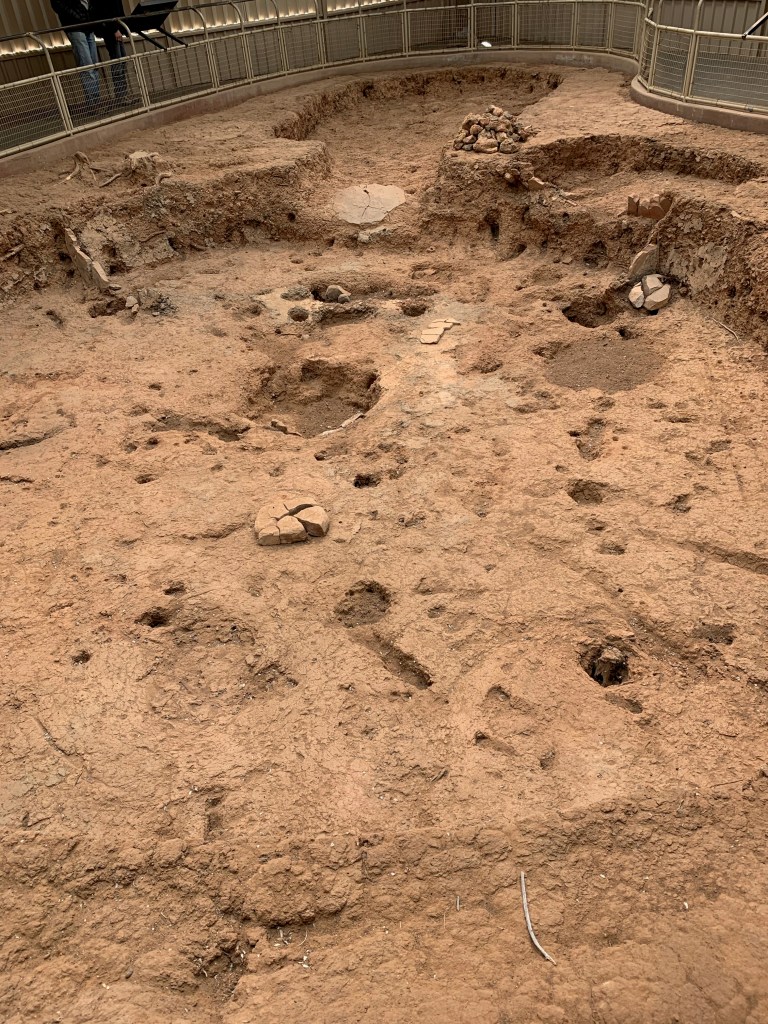
This one was built around 700 AD. It’s 2.5 feet deep and would have been surrounded by posts with wattle and daub between them, like we see at Angel Mounds. The oval at the top of the picture was the entry way, the rectangular extension of the pit at 2:00 was essentially the pantry. Grain, dried berries and nuts, and other stable goods were stores there. That’s the actual pit with very little excavation. Later pit houses were deeper and slightly larger. The last stage of their construction was the cliff dwellings. No one understands why they moved from pit houses on top of the mesa to cliff dwellings or why they eventually abandoned them.

Two life birds added today, a Clark’s Nutcracker and a Mountain Bluebird. I’ve seen them both in the distant past but never reported them to ebird until now. Saw a probable Ferruginous Hawk but won’t report it because I’m not sure of the ID. Saw 5 species of birds total, the above 3, house finch and junco!

Finished at 3:00 PM. Took Sammy to the Cortes dog park, he loved it. Them pow wowed on tonight and tomorrow. Decided to take the plunge and go for Big Bend. We’ve had enough cold weather and aren’t quite ready to go home. We are in the parking lot of Gallup NM’s Craker Barrel. There are 6 other RV’s here Should get to Big Bend day after tomorrow.

Moab, drive to Cortes, Mancos

We drove from Canyonlands to Moab to replenish groceries. Ate at a food truck (Quesadilla Mobilla), the number one rated “restaurant” in Moab on Trip Advisor. It was very good. Then we took Sammy to the dog park, he loved it, then on the road to Cortes and a Harvest Host site called Mancos Pizza. Mesa Verde is 9 minutes away. Mancos is a microbrewery. The beer we had was very good, the food was fine. The parking lot is 50/50 mud and gravel and I got stuck driving to the RV site where the gravel peters out and is mostly mud. One of the owners has a tractor out back and pulled me out. On the way here we stopped at a small park in Cortes to bird watch. Two new life birds, Cinnamon teal and Marsh Wren. Then we noticed another dog park. Sammy loves being chased by other dogs so we spent 30 minutes there before coming to Mancos Pizza. On to Mesa Verde tomorrow.

Canyonlands NP

The drive from Arches to Canyonlands was only about 35 minutes. Canyonlands NP is divided into three sections by the two rivers that dominate it, the Colorado and the Green. Their confluence makes a Y that is in the center of the park. We drove into the center of the Y, called Island in the Sky. The eastern side of the Y is Needles, the western side of the Y is the maze, there are no paved roads into it. The road from the east which we took dead ends at the cliff above the rivers. The entrance to the Needles is from the south, over an hours drive from where we started at Arches. Canyonlands was the least interesting of the parks. Here is a picture of the Green river from the cliff above it.

I’m standing about 10 feet from the edge. If it looks like a wasteland or moonscape to you, it did to us too. The river turns left and meets the Colorado. There is another vista point overlooking the confluence, it looks just like this picture but you can’t see either river, they are too deep in the canyon. The La Sal mountains could be seen from Canyonlands.

The Colorado river is down there somewhere.

We got to camp inside the park again, 3 for 3 now. This time we got a spot in a first come first serve CG. The main campground is in Needles section, it requires a reservation. We didn’t go to Needles and on a whim drove through the small campground in Island in the Sky and got lucky again.

It snowed hard on the campground starting around 9:30. I was seriously worried for a while, but it only lasted about 20 minutes. All snow was a melted by 9:30 when we left.

One new bird, Juniper Titmouse. Not rare at all but I hadn’t seen one yet. The two I saw were one of only three species I saw in the park.

Arches AM 3/24

We finished seeing Arches in the morning, drove on to Canyonlands around 11 AM. The single best site at Arches was Landscape Arch….

Landscape Arch

A thin ribbon of sandstone, the trail no longer goes under it. In 1991 it did. Visitors were sitting under it when they heard cracks and loud snaps followed by falling rocks. They scurried out from under it just before 180 tons of rock from under the arch fell. It made a sound like thunder that could be heard miles away. The trail has been rerouted around the arch although the park service is considering reopening the old trail since the arch appears stable. After this we went to Sand Dune arch and then Park Avenue, then off to Canyonlands. There was a long line of cars to get into Arches, the park sure to be closed due to too many cars very soon. No new birds today.

Arches NP

We got to Arches early, about 8:15 AM. There is basically one road, head into the park on it and at the end of the road turn around and head out. Three or four short side roads exist. One of these is to the campground. We had planned to ‘boondocks’ tonight on BLM ground but a short drive into the campground led us to 3 open sites. Found the host and got one for the night. This despite a campground full sign and a no sites available message on recreation.gov. We’re two for two this way. Maybe our luck will hold at Canyonlands tomorrow.

Arches is high desert, similar to the other parks but the geologic layers differ somewhat so that arches or natural bridges are more likely to be formed. When softer sandstone below erodes it leaves the harder sandstone above.

Windows, there were several of these. They are eroded holes in “fans”. Fans are the harder sandstone left after the surrounding soft stone erodes away. The windows are places where softer sandstone had insinuated itself
Double arch, probably our favorite.

There were multiple variations on that theme. We had a brief spell of warmth adequate to sit outside and read or relax without bundling up. Around 4 PM it began to get cold again.

Here is our campsite. You can see we used the blocks Will gave me for Christmas to level the camper van. (people keep asking us about it, Peggy has started saying “just look it up on the ModVan website)

We took about 5 short hikes, the longest about a mile. After seeing how things work I’m sure they closed the park yesterday when the number of cars exceeded the number of parking spots at the various attractions. At double arch for example, there are roughly 75 spaces to park. We got one of the few available, and it was still only 10 AM. By noon it was hard to find a parking spot at any of them.

Tomorrow we plan to go to Canyonlands NP tomorrow and maybe snag another open spot in the “full” campground. If our luck doesn’t hold out we’ll boondocks somewhere. Day after we’ll head for Mesa Verde.

No new birds today. Actually almost no birds at all, this place is almost devoid of wildlife. Turns out water is necessary for life. I literally saw three species today, white crowned sparrows (6 of them), Ravens (numerous), and Woodhouse’s Scrub Jay (2), and one rabbit.

Valley of the Goblins State Park, and Black Rosy-Finch

This state park was other-worldly. Pictures are in order….

The first person of European heritage to see them called this Mushroom Valley, but the Native Americans had called it Valley of the Goblins in there language, so that’s what the place eventually came to be called. Apparently this area was once a sand dune covered shore of a vast inland sea. The sand dunes were compressed into soft sandstone. As wind and water, very little water note the almost complete lack of vegetation, eroded the soft sandstone, hardened areas within the dunes remained to create these weird structures.

On the drive out of Capitol Reef I noticed a flock of small dark birds, pulled over and got a good look at about 40 Black Rosy-Finches. This is the best life bird of the trip. Look it up, gorgeous little bird. There may have been the other Rosy Finch, Gray-crowned, mixed in but I couldn’t be sure, so won’t count that species.

Arches NP closed!

We got to Arches around 1:30 PM and it was closed due to overcrowding. I don’t think this had anything to do with covid, at least not directly. I think there are just so many people here. Last night in Capitol Reef it got down into the 20’s, 40’s during the day yesterday, yet all the campsite were occupied, people were outside, kids playing and riding bikes.

Not only was Arches closed, every campground is full, as is every RV park. We did find one with a single “less than optimal site” according to the owner. We looked at it and decided this was our hotel night. Moab is a touristy western town close to both parks. It was a stop on the old Sante Fe trail when this was part of Mexico. We found a hotel (The Virginian) that takes pets there, and a decent restaurant (Gloria’s Cafe). The hotel is next to a river walk. After eating we took a walk on it only to find a dog park. Sammy is nuts about dog parks. He teases the other dogs into chasing him, and he runs constantly. If he realizes he’s no longer being chased, he makes full speed running passes at other dogs. If that doesn’t work he gets in their face and dares them to catch him.

We hope to get into Arches tomorrow AM, and maybe even see Canyonlands, its so close. We may boondock tomorrow. Then, if we feel like we’ve seen enough of Canyonlands, on to Mesa Verde.

Capitol Reef NP

Always be skeptical of a Campground Full sign. We left Ruby’s Best Western RV park Sunday without a definite spot to stay the night. We had a spot reserved in Capitol Reef NP for Monday through recreation.gov but they were supposedly full Sunday. We went to the campground host and asked, found out they had 3 open sites? One of them was the same spot we had for Monday (tonight). Same story tomorrow, leaving for Canyonlands NP without a place to camp, let’s hope they will have a few open spots.

Capitol Reef is roughly 5X the size of Bryce Canyon. Rugged cliffs, sparse vegetation and cold, it got down into the 20’s last night. The park only opened March 1 but there are lots of people here. We went to the waterfold today, a 100 mile shear cliff that is the reef in the park’s name. The early pioneers likened it to a barrier reef as it prevented them from traveling, like a reef blocks a ship. There are several narrow gorges where the rare rain storm washes through the cliff. Pioneers and the Indians before them used these washes to travel through. The park gets 10 inches of precipitation a year, but the occasional summer thunderstorm is dangerous. There is no soil here, just rock and sand so the water doesn’t soak in at all, just runs off, when it hits the waterfold, the cliff, it flows until it reaches one of these gaps. The water level can get several feet high in minutes.

In case you’re wondering. The Capitol part of the park’s name comes from the resemblance of the park’s major mountain peak to the US capitol dome.

We also hiked the Freemont river trail and the Hickman arch trail.

Eating right now at a triple D, and roadfood.com place, Curry Pizza Palace in Bicknell Utah, using their internet. The pizzas are naan bread with indian toppings. We had half chicken masala and half butter chicken. I couldn’t tell the two halves apart, Peggy, who is a super taster could. Both were good. Wish us luck, 3 inches of snow tonight, and tomorrow we move on to Canyonlands, then Arches, then Mesa Verde, if all goes as planned.

One of many orchards around the Fruita CG at Capitol Reef NP. Apple, cherry, plum and apricot orchards are here. Fruit is available to park visitors on a you pick it basis in the summer.
We hiked into one of the gaps in the waterfold. It was a foot path due to large boulders until pioneers spent 4 years clearing them in the 1990’s so that wagons could pass.

Bryce Canyon NP

On a very cold windy day we drove through Bryce Canyon stopping at all the turnouts and taking short walks. Busy but not congested like Zion NP was, this park the drive is on the rim of the canyon while Zion is on the canyon floor. The views at Bryce are spectacular and the geology very interesting. Off white limestone, or dolomite, is on top, followed by several layers of red rock, then shale then sandstone. Most of the images won’t upload, connection is poor, may try again later.

The Three Monkeys Hoodoo. The one on the left has his hands over his eyes, etc.

We plan to go to Capitol Reef NP tomorrow, Arches Tuesday and Canyonland Wednesday and/or Thursday. Mesa Verde in Colorado is probably next. All of the drives if done in that order are less than 3 hours.